
【星岛综合报道】位于亚省麦克默里堡(Fort McMurray)东南方向的北部社区德雷珀(Draper)已发布疏散警报,原因是克利尔沃特河(Clearwater River)冰层融化,开始漫过河岸。
当地紧急事务官员表示,麦克默里堡附近阿萨巴斯卡河(Athabasca River)上的冰塞 (ice jam,指冰块在河流中堆积、堵塞的物理现象) 导致克利尔沃特河水位上升,该社区所有居民都应做好随时撤离的准备。
这个在阿萨巴斯卡河上形成的冰塞长约20公里,一直受到当局密切监测。
@fortmacexclusives Ice Jam Watch Issued For Fort McMurray As River Breakup Conditions Shift. Staff at Haxton Centre have evacuated as a precaution. Footage is of Hangingstone and Clearwater near waterways today April 27th 12pm The province has issued an Ice Jam Watch for the Athabasca River from Pelican Rapids to Fort McMurray, according to Alberta Rivers. Alberta Rivers says ice jam locations and flooding impacts can be unpredictable, and people near affected streams should be cautious of rapidly changing water and ice levels. According to 103.7 Play, officials say an ice jam has formed upstream, just south of the community. Ice is still reportedly intact through town right now, but conditions can change quickly and without warning. There are also reports that staff at the Haxton Centre were asked to leave as a precaution because the current road access is not protected by flood mitigation. RMWB previously noted that work is still planned this season to restore the original Haxton Centre access and rebuild the flood protection berm in that area. Provincial river forecasters are surveying the river from the air today, and RMWB says a more detailed river breakup update is expected later today. This does not mean Fort Mac is flooding right now, but it does mean the risk level has increased and the next updates matter. Follow Exclusives and check our story for more ✅ Sources: Alberta Rivers, RMWB, 103.7 Play
周二最新亚省河流监测的数据,此冰塞已使克利尔沃特河水位上升4.5米,阿萨巴斯卡河水位上升5.5米。
德雷珀是伍德布法罗地区自治市(Regional Municipality of Wood Buffalo)的一个小型乡村社区,人口137人,位于麦克默里堡东南约12公里处,沿河而建。
公告警告称,水位可能影响花园巷(Garden Lane)和河湾巷(River Bend Close)的通行。截至周二上午,花园巷的部分路段已被大水冲毁。
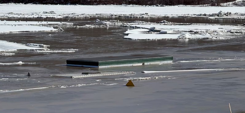
(随着河流水位上涨,一辆拖车和一个货柜几乎完全被淹没在麦克默里堡市中心。 CBC)
当局建议德雷珀的所有居民准备一个72小时应急包,制定应急计划,并密切注意当地应急官员发布的紧急通知。
官员敦促该地区的居民检查他们的房屋保险单,并告知紧急应变人员是否有需要协助撤离的邻居。
每年春季河水融化通常会带来水浸风险,近几日,随着克利尔沃特河和阿萨巴斯卡河水位开始上涨,紧急官员一直在密切关注。官员警告,未来几天冰情可能会在几乎没有预警的情况下发生变化,尤其是在气温升高的情况下。
麦克默里堡有悠久的水浸历史,主要原因是阿萨巴斯卡河和克利尔沃特河交汇处的冰塞所致。虽然该地区几十年来记录了多次水浸,但2020年4月的水浸被认为是百余年来最具破坏性的。
那年春天,阿萨巴斯卡河上一条长达25公里的巨大冰塞导致水位急剧上升,洪水淹没了麦克默里堡市中心,约13,000名居民一度流离失所,市中心地区1,200多栋建筑物受损,造成 5 亿元的损失。
图:Facebook/Mike Jones
v01
